|
GPS (Global Positioning System) is the term for a world-wide navigational system, to be used for precise determination of position, route, distance, altitude, time and movement relative to the earth's surface, with the aid of a pocket-sized instrument which comfortably fits into a person's hand. It is valued by pilots, mountain climbers, tourists and travelers, ham radio fans, geologists and all globetrotters.
The GPS system was developed by the Ministry of Defense of the United States, initially for use by the Airforce and Navy. The core of this navigational system consists of 24 navigational satellites that orbit the earth on six different, very precise tracks with an angle of 55 degrees in relation to the equator. The positions of the satellites are calculated so that at any given moment at any place on the planet a sufficient number of satellites are visible above the horizon to enable a precise measurement of position. It has been verified that over the territory of our republic, at any time of day or night, at least 6 to 8 satellites of the GPS system are located above the horizon.
The precision of measurements of position is given by the principle of emitting and processing exact time signals which the satellites continuously broadcast, at a frequency of around 1.57GHz, and achieves an unbelievable 15 meters. For reasons of fear of misuse of these precise location measurement possibilities by terrorist organizations, an intentional coded deviation, (Selective Availability Program) which decreases the precision of position determination to around +/-50m.
The Ministry of Defense of the United States is considering dropping this intentional deviation in the future and thereby substantially increasing the maximum possible precision, but judging by the current worldwide security situation; this change probably cannot be expected in the next few years.*
|
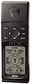 The GPS Instrument contains a very sensitive signal receiver in the 1.5GHz band, a precise time signal source (clock) and a powerful mathematical processor. All is encased in an ultrasound hermetically sealed cover, which is filled with nitrogen. All display and communication with the user is via a clear LCD screen, graphic system menu, acoustic signals and flat buttons on the face panel of the instrument. The dimensions of all the pocket navigational systems are around 15x5x3cm and their weight is approximately 250g. Power supply is by normal AA batteries, alkaline, NiCd, NiMH or an external source of 10-40V, from a car for example. Power consumption of the GPS instrument is above 100mA however, which places extremely high demands on power sources. Furthermore, these instruments use a small amount of power even when switched off, which is necessary for memory of user data.
Individually the instruments differ from each other somewhat, mainly in the maximum power consumption (8-40V), the type of miniature antenna of the receiver, (internal, external), number of receiving channels (8,12) maximum measurable speed (166 km/h, 1850 km/h), maximum number of savable route points, (250, 500), and battery life, (12-24 hours).
Most of the instruments are equipped with a connector for connecting two instruments together or the instrument to a personal computer. Supplied software then allows not only to download data from the instrument, display it or save it on a computer, but also to input individual location points from the computer, arrange them into routes for various trips and determine distances to interesting goals. After transferring this data from the computer to the instrument all that remains is to head out into the sky into the arms of new adventures.
|